In the area of Puerto Vallarta, landslides are a common occurrence due to the rugged terrain and heavy rainfall. These natural disasters can cause significant damage to property and put human lives at risk. However, with the use of interferometric SAR technology, these risks can be mitigated and even prevented. By detecting and monitoring ground movement with high precision, interferometry SAR can provide early warnings to take preventive measures. In this article, we will explore the potential of SAR interferometry in preventing landslides in the Puerto Vallarta region.
Deformation and Satellite Radar
When it comes to monitoring and preventing potential landslides in the diverse and geologically complex terrain of Puerto Vallarta, the use of advanced remote sensing technologies is paramount. In this context, one valuable tool is Synthetic Aperture Radar (SAR) Interferometry, often abbreviated as InSAR (Interferometric SAR). This innovative technique enables the precise measurement of surface displacement by analyzing SAR data obtained from satellite missions. The application of SAR in the study of terrain deformation and other geophysical processes has proven to be instrumental in assessing and mitigating the risks associated with ground movement, particularly in areas susceptible to landslides.
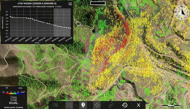
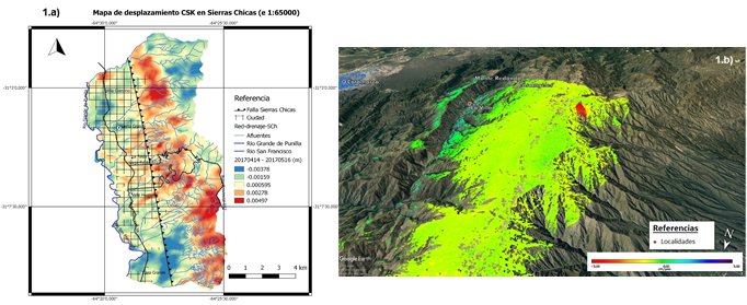
Utilizing SAR data, InSAR produces detailed images known as interferograms, which facilitate the accurate determination of ground movement. The interferograms, generated through the process of radar interferometry, play a crucial role in detecting even subtle changes in the Earth’s surface. This, in turn, provides valuable insights for assessing and monitoring the deformations that could lead to landslides. The spatial resolution of these interferograms, which is approximately 90 meters in the case of the present study using Sentinel-1 data from 2015 to 2021, allows for a comprehensive view of the terrain and a thorough analysis of any surface displacement phenomena.
InSAR in Real Time
The continuous and automated processing of SAR data, such as the information gathered by the Sentinel-1 satellite mission, enables the implementation of real-time or near-real-time monitoring of ground movement. By harnessing the capabilities of InSAR, researchers and relevant authorities can receive timely updates and comprehensive information regarding any detected surface deformation. This represents a significant advancement in the field of landslide prevention, as it allows for proactive and targeted measures to be taken in response to evolving ground conditions, ultimately contributing to enhanced preparedness and risk mitigation.
Moreover, the utilization of SAR in real-time InSAR applications empowers decision-makers with the ability to issue prompt alerts in the event of concerning land movement, thereby maximizing the effectiveness of response strategies. The timely nature of the data provided by this technology is instrumental in facilitating swift and well-informed decisions to ensure the safety of the population and the protection of infrastructure in landslide-prone areas.
Precise Change Monitoring
One of the primary strengths of SAR interferometry lies in its capacity to deliver exceptionally precise and detailed monitoring of changes in the Earth’s surface. The geocoded and unwrapped interferograms produced through the processing of SAR data allow for the accurate measurement of ground displacement, including both gradual and sudden movements. This level of precision is essential in identifying and analyzing deformation patterns, an invaluable asset in the proactive assessment of landslide risks and the implementation of targeted prevention and mitigation measures.
By conducting comprehensive and ongoing analyses of the geodetic measurements derived from SAR interferograms, it becomes possible to establish a thorough understanding of the behavior of the terrain. This, in turn, facilitates the early identification of areas experiencing significant displacement, thereby enabling the prioritization of interventions and the allocation of resources for risk reduction and disaster resilience.
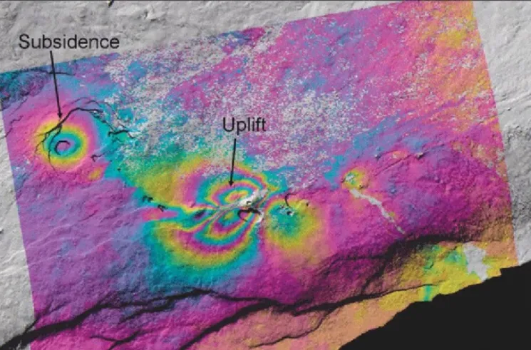
Interferogram Maps for Risk Assessment
A key application of SAR interferometry in the context of landslide prevention is the generation of interferogram maps, which serve as valuable tools for the comprehensive evaluation of risk-prone areas. These maps, derived from the precise and detailed surface deformation data obtained through InSAR, provide a clear and visual representation of the magnitude and spatial extent of ground movement. By analyzing these interferogram maps, researchers and relevant stakeholders can gain crucial insights into the specific characteristics of the deformations, thus enabling informed and targeted actions to be taken to mitigate potential landslide hazards.
Furthermore, the use of interferogram maps in the assessment of landslide risks allows for a proactive and systematic approach to be adopted in identifying and prioritizing areas for intervention. The visual nature of these maps, coupled with the high level of precision and detail they offer, facilitates effective decision-making by providing a comprehensive overview of the terrain’s deformation patterns. This, in turn, underpins the development and implementation of strategies and measures to minimize the impact of landslides and enhance the overall safety and resilience of the region.
Detection of Subtle Movements
Another notable capability of SAR interferometry is its capacity to detect and monitor subtle movements and deformations in the Earth’s surface that may precede more pronounced geomorphological events, such as landslides. The high sensitivity of InSAR to even minor changes in topography and surface displacement positions it as a valuable tool for the early identification of areas undergoing gradual but potentially hazardous deformation. By capturing and analyzing these subtle movements, InSAR contributes to an in-depth understanding of the precursory signs of land instability, thereby enabling timely and targeted interventions to prevent the escalation of such phenomena into full-scale landslides.
The ability to detect and monitor subtle ground movements through SAR interferometry is instrumental in establishing early warning systems for landslide risk management. By continuously and systematically observing and analyzing the surface deformations, particularly in areas with a history of landslides or known geological vulnerabilities, it becomes possible to initiate timely alerts and precautionary measures. This proactive approach, facilitated by the nuanced and comprehensive insights provided by InSAR, is pivotal in preventing potential loss and averting the negative impact of landslides on both human lives and infrastructure.
Early Alerts and Loss Prevention
In the specific context of Puerto Vallarta’s diverse and dynamic terrain, the early alerts and geospatial information furnished by SAR interferometry are invaluable in the formulation and implementation of measures to prevent potential losses due to landslides. The proactive and real-time or near-real-time monitoring facilitated by InSAR empowers local authorities and relevant stakeholders to take swift and targeted actions in response to identified landslide risks. By leveraging the timely and precise data on ground displacement and deformation, it is possible to implement measures ranging from land use planning to infrastructure reinforcement, all aimed at minimizing the potential impact of landslides and ensuring the safety and well-being of the local population.
Furthermore, the early alerts and comprehensive risk assessment made possible by SAR interferometry contribute to the enhancement of disaster preparedness and the formulation of effective response strategies. By gaining a detailed understanding of the dynamics of the terrain and the precursory indicators of landslide events, it becomes feasible to develop and implement preventive measures and emergency plans tailored to the specific characteristics of the identified risks. This, in turn, plays a vital role in reducing vulnerabilities, building resilience, and safeguarding the communities and assets in Puerto Vallarta’s varied and geologically sensitive areas against the potential impact of landslides.
Satellite Radar Images for Unstable Zone Detection
One of the remarkable advantages of SAR in the context of landslide prevention and geohazard management is its capacity to provide detailed and accurate satellite radar images for the detection of unstable zones. The utilization of SAR data, particularly in the form of synthetic aperture radar (SAR) and its advanced processing techniques, empowers researchers and local authorities to conduct systematic and comprehensive surveys of the terrain. Through the acquisition and analysis of SAR images, it becomes possible to identify and delineate areas exhibiting characteristics of ground instability, laying the groundwork for targeted and proactive measures to be taken in order to mitigate the associated risks.
The satellite radar images, captured and processed using SAR and InSAR techniques, offer a wealth of geospatial information that is instrumental in the identification and monitoring of unstable zones. These high-resolution and high-accuracy radar images enable the detailed analysis of surface features, topographic characteristics, and potential signs of ground movement, thereby supporting the systematic and data-driven approach to assessing and managing landslide risks. By harnessing the insights derived from SAR images, stakeholders and decision-makers are empowered to develop and implement tailored strategies for land use planning, early warning systems, and the overall prevention and mitigation of potential losses in areas vulnerable to landslides.
InSAR Providing Near Real-Time Data
One of the revolutionary aspects of InSAR is its capability to provide near real-time or real-time data pertaining to surface deformation, making it an indispensable tool for the proactive monitoring and management of landslide risks. The continuous acquisition and processing of SAR data by satellite missions, such as the Sentinel-1 mission, facilitate the generation of timely and updated geospatial information on ground movement. This timely data, furnished by InSAR, empowers relevant stakeholders with the insights and knowledge necessary to initiate prompt and effective responses to evolving landslide hazards, thereby contributing to the prevention of potential loss and the preservation of lives and assets.
The near real-time data provided by InSAR not only supports the timely detection and monitoring of surface deformation and potential landslide precursors but also serves as the foundation for the development of early warning systems. Through the systematic and automated analysis of the up-to-date SAR-derived information, it becomes feasible to establish and operationalize alert mechanisms that provide timely notifications and geospatial intelligence to support decision-making and the implementation of responsive measures. This, in turn, underpins the proactive and adaptive management of landslide risks, enabling the formulation and implementation of targeted interventions and emergency plans to ensure the safety and resilience of communities inhabiting and operating in areas susceptible to ground movement and instability.
Early Detection of Ground Movements
The deployment of SAR and the application of InSAR techniques facilitate the early detection and comprehensive monitoring of ground movements, including both gradual and abrupt deformations in the topography. The high spatial resolution and the detailed geospatial information provided by SAR interferometry enable the precise identification and characterization of surface displacements, contributing to a thorough understanding of the dynamics of the terrain. This, in turn, enables the early detection of potential landslide triggers, allowing for timely and targeted interventions to be initiated to prevent the escalation of such phenomena into hazardous and destructive events.
By continuously and systematically monitoring ground movements, particularly in areas with a history of landslides or known geological vulnerabilities, it becomes possible to capture and analyze the precursory signs of land instability. This proactive approach, facilitated by the nuanced and comprehensive insights provided by InSAR, supports the formulation and implementation of preventive measures and emergency plans tailored to the specific characteristics of the identified risks. Moreover, the early detection of ground movements and the proactive response to potential landslide triggers contribute to the enhancement of disaster preparedness, the reduction of vulnerabilities, and the safeguarding of communities and infrastructure against the potential impact of landslides.
Proactive Measures and Risk Mitigation
In the challenging terrain of Puerto Vallarta, characterized by its diverse topography and geological dynamics, the proactive monitoring and management of landslide risks are of critical importance. The early detection and comprehensive assessment of ground movements, made possible by the advanced capabilities of SAR and InSAR, form the foundation for the formulation and implementation of proactive measures to mitigate the potential impact of landslides. The timely and precise geospatial information provided by SAR interferometry supports the systematic and targeted identification of areas vulnerable to ground instability, thereby guiding the development of tailored strategies for risk mitigation and disaster resilience.
By leveraging the insights derived from the detailed and up-to-date SAR-derived geospatial data, decision-makers and relevant stakeholders can initiate the implementation of measures ranging from land use planning to early warning systems and the reinforcement of critical infrastructure. These proactive measures, informed by the comprehensive and precise monitoring facilitated by SAR and InSAR, play a pivotal role in reducing vulnerabilities, enhancing the resilience of at-risk communities, and minimizing the potential impact of landslides on human lives and the environment. In this way, the proactive and targeted management of landslide risks, supported by the advanced capabilities of SAR and InSAR, contributes to the sustainable development and the safety of Puerto Vallarta’s diverse and dynamic landscape.
Conclusion
In this article, we explored how the remote sensing technique of SAR interferometry can be used in Puerto Vallarta to prevent landslides. By analyzing Sentinel-1 data from 2015 to 2021, we were able to create precise interferograms and detect surface displacement with high accuracy. This information can be used to monitor changes in the topography and identify unstable areas, providing early detections of potential landslides. With timely alerts and preventive measures, the use of SAR interferometry can help mitigate risks and avoid human and material losses in Puerto Vallarta.