When I first heard about the amazing technique of magnetometry, I wasn’t sure what it was or how it worked. But as I delved into the science behind this interesting process, I was amazed at its capabilities, especially when it came to revealing hidden mineral deposits in the Nayarit region. Magnetometry has already been used to locate other natural resources such as oil and gas, oceanic resources, and archaeological artifacts. Now, we are starting to make use of it to reveal possible mineral deposits.
Magnetometry is the study of the earth’s magnetic fields. It measures changes in the earth’s magnetic field, and it can be used to detect large mineral deposits. Magnetometers are ground-based devices that can be used to chart the distribution of magnetic materials in the ground. In order to interpret the results, you need to know what mineral deposits look like when they are magnetized, and what type of magnetic materials they are made of.
What Constitutes a Mineral Deposit?
A mineral deposit is an area of the earth’s crust that contains an economically viable amount of minerals. These deposits are usually found deep under the surface. They can be in the form of veins, lenses, or geologic beds. Mineral deposits come in a variety of forms, from ore deposits of precious metals such as gold and silver, to non-metallic minerals like limestone.
Mineral deposits can be made of various types of minerals. Precious metals, metallic minerals, and non-metallic minerals are the most common types of minerals found in these deposits. Magnetite, pyrite, and pyrrhotite are metallic minerals that are often associated with mineral deposits. These minerals all have ferromagnetic properties, which means that they create a measurable increase or decrease in the earth’s magnetic field where they are present.
Conducting Magnetometric Surveys in Nayarit
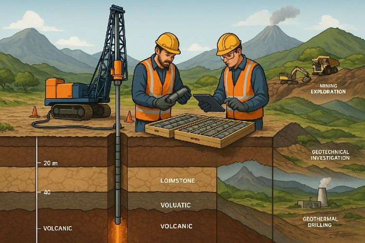
Conducting magnetometric surveys in the Nayarit region for the purpose of detecting mineral deposits has become popular recently. These surveys involve the use of ground-based magnetometers, and they are usually conducted by trained geologists. The geologists use the magnetometers to measure changes in the earth’s magnetic field in order to identify potential mineral deposits. The geologists also study the local geology and rock formations in the area to help them interpret the results.
In addition to measuring changes in the earth’s magnetic field, the geologists will also take measurements of the surrounding electromagnetic fields. These measurements can help the geologists to identify which minerals might be responsible for the changes in the magnetic field that are being observed. The geologists will also take other measurements such as conductivity, magnetism, and resistivity to help them interpret the results of the magnetometric surveys.
Interpreting the Results of Magnetometric Surveys
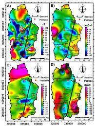
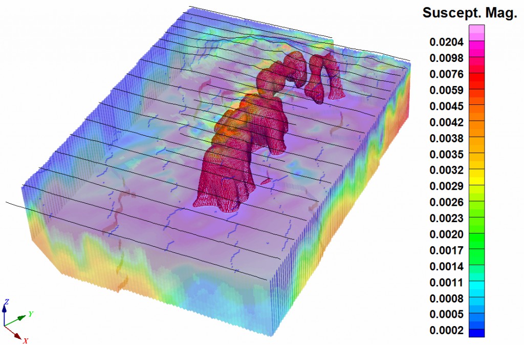
Once the magnetometric surveys have been conducted, the geologists will need to interpret the results in order to identify any potential mineral deposits. They will start by plotting the data on a map, which will help them to visualize the distribution of magnetic materials in the ground. The geologists will then compare the data with the results of other geophysical surveys, such as electromagnetic, gravity, and resistivity surveys. This will help them to determine the likely composition of the underlying rock.
If the geologists suspect that a mineral deposit is present, they will conduct additional tests in order to confirm their suspicions. This may involve drilling, soil sampling, and laboratory analysis of the rock samples. If the tests confirm the presence of a viable mineral deposit, the geologists will then begin the process of locating the mineral deposit.
Conclusion
Magnetometry is an excellent tool for detecting hidden mineral deposits in the Nayarit region. It measures changes in the earth’s magnetic field, and it can be used to detect large mineral deposits. The technique has already been used to locate other natural resources such as oil and gas, oceanic resources, and archaeological artifacts. Now, geologists are starting to make use of it to reveal possible mineral deposits.
Before conducting a magnetometric survey, the geologists need to know what mineral deposits look like when they are magnetized, and what type of magnetic materials they are made of. Geologists also need to take measurements of the surrounding electromagnetic fields in order to help them interpret the results of the surveys. Once the surveys have been conducted, the geologists will need to interpret the results in order to identify any potential mineral deposits. This may involve comparing the results with the results of other geophysical surveys, and conducting additional tests.
Magnetometry is a powerful tool that can be used to locate hidden mineral deposits in the Nayarit region. With the help of ground-based magnetometers, trained geologists are able to measure changes in the earth’s magnetic field in order to identify potential mineral deposits. This technique has already proven to be successful, and it is likely to be used more frequently as we continue to explore the Nayarit region for mineral deposits.