The state of Nayarit in Mexico is known for its beautiful beaches, lush vegetation, and diverse culture. But it’s also a place that’s rapidly growing and evolving, and with that growth comes the need for smarter, more efficient infrastructure development. One way to improve the planning of infrastructure projects in Nayarit is through the use of applied geophysics. The study of the physical properties of the earth, geophysics can provide valuable information for the design and construction of roads, bridges, tunnels, and other key infrastructure. In this article, we’ll take a look at some of the key benefits of applied geophysics in the planning of infrastructure projects in Nayarit.
Improved Understanding of the Ground’s Properties
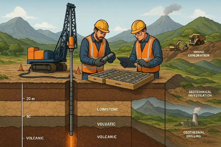
One of the key benefits of using applied geophysics in the planning of infrastructure projects is the ability to gain a more detailed understanding of the ground’s properties and how they can affect construction. By using geophysical methods such as seismic reflection, gravitational surveys, and electrical resistivity tests, engineers and planners can map out the different layers of soil, rocks, and other materials that make up the ground. This information can be used to determine the best location for roads, bridges, and other infrastructure, as well as to identify any potential hazards that could impact the construction process.
Identification of Underground Hazards
Another important benefit of using applied geophysics in infrastructure planning is the ability to identify and locate hazards that are buried underground and can pose a threat to construction projects. Whether it’s an old mine, a gas line, or an underground water source, these hazards can be difficult to detect and can have a major impact on project timelines and budgets. Geophysical methods such as ground penetrating radar and electromagnetic surveys can be used to identify and map out these hazards, allowing engineers to better plan for construction and avoid potential problems.
Cost Savings
The use of applied geophysics in infrastructure planning can also lead to significant cost savings. By gaining a better understanding of the ground’s properties and identifying buried hazards, engineers can avoid costly mistakes and delays in construction. This can lead to millions of dollars in savings over the course of a large-scale projects. Additionally, geophysical methods can be used to better assess the risks associated with different construction methods, helping to identify the most efficient and cost-effective approach to infrastructure development.
Increased Safety
For any infrastructure project, safety is a top priority. The use of applied geophysics can significantly improve safety by providing engineers with valuable information about the ground’s properties, as well as any hazards that may be present. This information can be used to design construction methods that reduce the risks of accidents and injuries, and to ensure that all necessary safety precautions are in place before construction begins. As a result, the use of applied geophysics can significantly improve safety on construction sites, leading to a better overall experience for both workers and the surrounding community.
Conclusion
The state of Nayarit is rapidly growing and evolving, and with that growth comes the need for smarter, more efficient infrastructure development. One way to improve the planning of infrastructure projects in Nayarit is through the use of applied geophysics. The study of the physical properties of the earth, geophysics can provide valuable information for the design and construction of roads, bridges, tunnels, and other key infrastructure. By gaining a better understanding of the ground’s properties, identifying underground hazards, and reducing costs and improving safety, applied geophysics can be a valuable tool for infrastructure planning in Nayarit.